6 months ago
founders
Let Us Begin!
Geoflow is an open source, node orchestration application specifically built for the Geospatial industry.
September 3, 2025 • by Jordan Rising • 6 min read
Let us begin!
This is a brand new project, our very first blog post, so naturally I’m sitting here stressing over the perfect way to introduce Geoflow, but all I can think of is movie quotes. Humor must be my stress coping mechanism… For the cultured and sophisticated reader, the quote above is from the greatest movie of all time (objectively speaking) - Dumb and Dumb. If you haven’t seen it, I’d suggest not wasting any more time reading this and go watch it. But if you’re hanging around, we are thrilled to announce we are building something new: Geoflow.
What is Geoflow?
Well, we can give you our answer for today, but real the answer will likely morph in the coming months. Geoflow is an open source, node orchestration application specifically built for the Geospatial industry. If you have ever heard of n8n or make.com, it’s a similar concept but architected to the specific needs of geospatial.
Geoflow is an application designed to automate GIS workflows. A Workflow is a collection of processes, called nodes. A node can be something simple like reading the contents of a file, or something more sophisticated like running ground classification on a point cloud. When you chain a bunch of these nodes together, you have created a Workflow.
Maybe an example helps articulate this better…let’s say I wanted to create a workflow to help automate our LiDAR processing. We can take all our normal processes, and break them into discrete nodes. Below is an example for the lifecycle of a typical topographic LiDAR project.
Manual Trigger → Read Files from input → Strip Align → Ground Classify → Clip to Polygon → Generate DTM → Generate Contours → Upload Deliverables
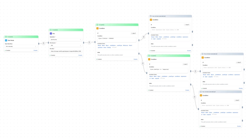
This workflow, despite being simple and relatively easy to conceptualize, has a tremendous amount of value. This is just a basic implementation of a workflow, but you can sprinkle lots of ‘extras’ on top of this. There conditions, branches, and triggers that could extend this workflow to many different use cases. Say instead of starting this workflow with a manual trigger (pressing the ‘Execute’ button), you would prefer that the workflow would start whenever a new file is added to a directory in Google Drive or AWS.
Workflows can be executed manually, from chatting with an LLM (more on this below), from a schedule (i.e. every day at 7am), from a webhook (new file added to S3), or from a completely separate workflow. The flexibility in how automations are created is nearly limitless
What About AI?
There are a handful of ways to incorporate AI into Geoflow, but the implementation we are starting with is Agentic AI. The beauty of AI Agents is that you can empower them with just enough context and tooling to do a handful of tasks accurately and predictably. For example, let’s say we build an AI Agent that has basic spatial querying tool calling. The ‘trigger’ for this Workflow is just simply chatting with the LLM (same way we all chat with ChatGPT or Gemini, etc). But it allows me to do some very simple, but powerful operations just from a chat.
“Can you find all the wood poles within 20 miles of XYZ location and send them to me as a kml?”.
It has tool calls for reading from common GIS inputs (csv, shapefile, kml, etc), calling the Spatial Query tool, and outputting to those same GIS file types. This workflow could be extended with more tools or less restrictive system prompting, but we find adding more Workflows that are finely tuned are more reliable and yield better results.
But this “AI Agent - Spatial Query” could be invoked by any Geoflow user to query and get spatial GIS results directly from chat alone. So this requires zero GIS experience, no special tooling, and can be invoked from your phone or anywhere you can access the chat.
Why Geoflow and Why Open Source?
The geospatial industry is one of the most procedural, data-rich fields out there. So much of this industry is based on standard, repeatable procedures. And yet, it’s an industry that has surprisingly little standardization and automation. Every organization ends up solving the same problems over and over, often with closed, siloed software.
We think the time is right for something different. Geoflow is our attempt to create a platform that is:
- Open Source in a Closed Industry Most geospatial tools are locked down. We want to build something anyone can use, extend, and adapt — without barriers.
- A Framework for Contribution Our vision is for Geoflow to be more than just our project. We want it to be a framework where developers, researchers, and organizations can contribute nodes and templates that others can build on.
- Flexible and Self-Hostable Geoflow will run where you need it: in your own cloud, on your local servers, or even on your laptop. You stay in control of your infrastructure and your data.
- AI-Ready, but Not AI-Only We’re designing Geoflow to connect with both frontier AI models (like GPT-5 and Claude) and local, open-source models (like those running on Ollama). Some workflows will use AI in an agentic way — “find me all the wood poles within 10 miles of this fire” — but many won’t use AI at all. The key is flexibility: the right tool for the right job.
- Built for Core Geospatial Workflows Early development is focused on point cloud processing, with tools for ground classification, thinning, reprojections, and more. These are the building blocks of larger, automated workflows.
- Remove Vendor Lock-in One of the biggest downsides of proprietary software - vendor lock-in. No one wants to invest their time and money into an application that may or may not be around in a few years. Although our intention is building this platform for the long run, if our whole team were to get “savagely get ripped apart by a school of hammerhead sharks (Superstar, 1999)”, you’d still own your own version of Geoflow and life would go on.
Get Involved Early
This is a brand new project, and we’d love for you to be part of its early days. Although we are extremely bullish on this, we know how important the community is for its success. We would love to see custom nodes and integrations built for all kinds of 3rd party apps & services.
If you’re a developer, researcher, or company interested in contributing — or just curious about where this is going — we’d love to hear from you. Reach out to us anytime at hello@geoflow.dev
Tags
#First Post
#Founders